Trimble® Stratus turns aerial views into working insights.
Utilize drones equipped with Trimble Stratus software to accurately map and measure your job site.
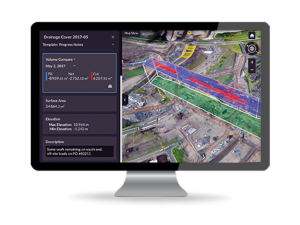
- Collect detailed topographical images of the job site as needed without hiring a survey crew.
- Track material and inventory volumes from pits, stockpiles, or drainage channels.
- Communicate effectively with visual timelines.
- Manage multiple sites with less in-person site visits with the ability to inspect work remotely.
- Safely survey high-risk areas.
- Compare actual surface to design surface.
- Measure site measurements easily.
- Get quicker answers with an intuitive, web-based tool.
- Generate and share interactive maps to collaborate from both the office and the job site.
Submit your contact information using the form below to schedule a demo of Trimble Stratus to see firsthand how it can help all stages of your construction projects. A SITECH Construction Technology Specialist will follow-up with your request.